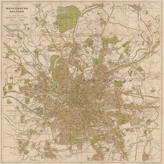
One of my favourite old maps of Manchester
 I have spent a good deal of time over the last couple of years looking at a wide array of maps of Manchester - old / new, pretty / ugly, useful / unworkable. One of the most attractive and effective maps I've come across is this early twentieth century street map produced by the cartography company G.W. Bacon & Co. Ltd.
The coverage of Bacon's Plan of Manchester and Salford feels just about right. Large enough to show most of the developed area but compact enough to be legible and easily usable as a sheet map. I really like the colour scheme, with its brown built up areas and green parks and recreation grounds. The symbol design is simple and clear, and the streets are well labelled.
Overall, the aesthetic leads to harmonious cartography and one that really captures the scale and shape of the city that was at its peak in many senses.
I have an original nicely framed and hanging on my kitchen wall. If you want to see this map in much greater detail I have also scanned it and put it online (warning its an 18 meg jpeg file).
An earlier version of Bacon's Plan of Manchester and Salford, dated to 1907, from the Manchester City Library's Local Studies Collection has been digitised and can be browsed on Rylands Library Luna service. The cartographic design is quite similar but the extent of urbanisation is somewhat less.


Comments
Post a Comment